This page may be viewed in:
The cleanup of the Lower Duwamish Waterway is a several hundred-million-dollar effort that takes time and needs to be done right. Once complete, the cleanup of contaminated sediment and pollution source control is anticipated to reduce over 90 percent of the waterway’s PCB sediment contamination.
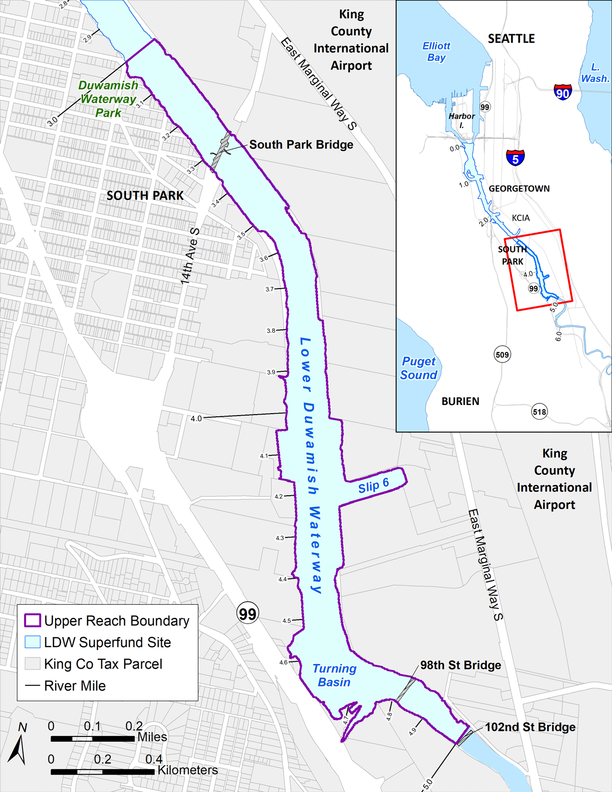
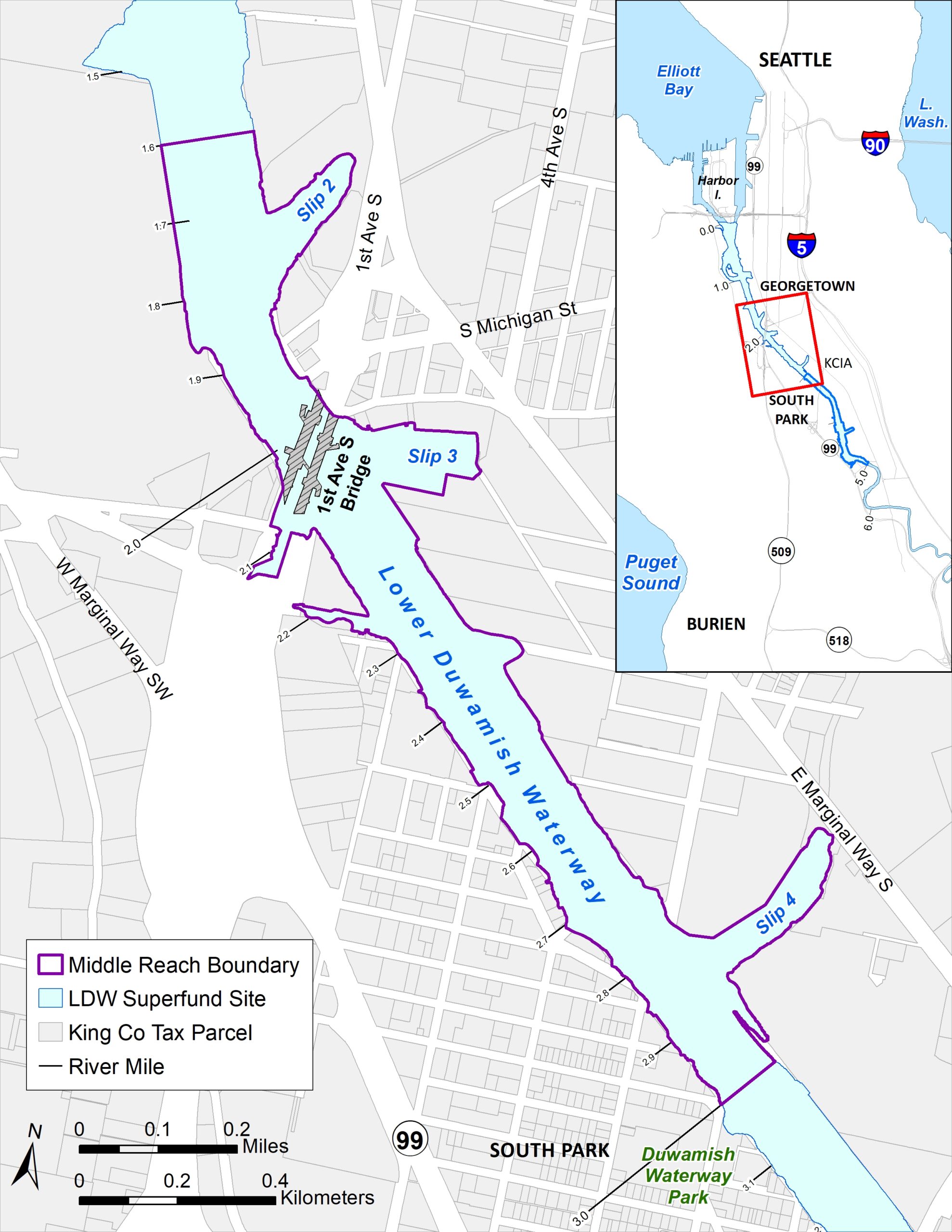
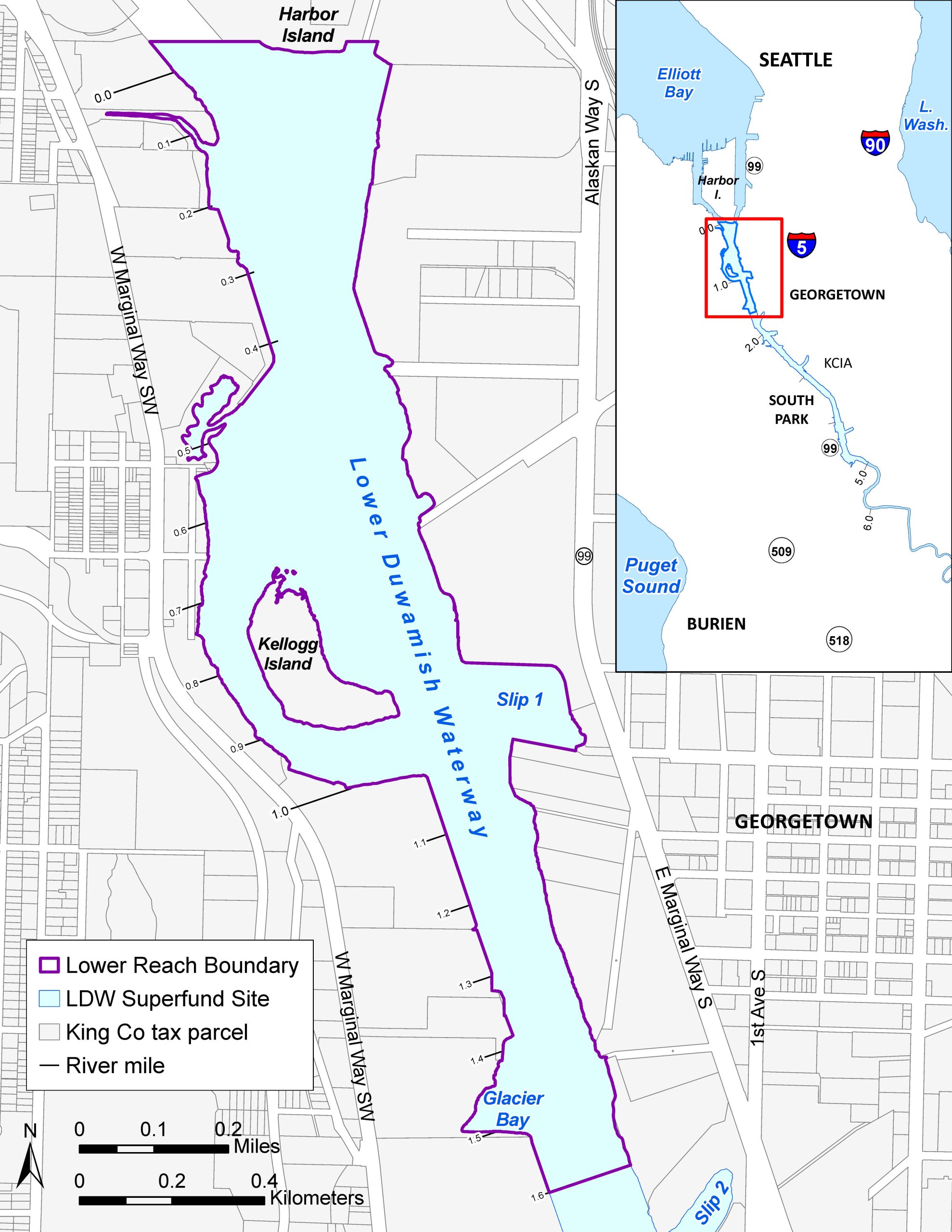
The Lower Duwamish Waterway Superfund site is divided into three reaches, or segments: upper, middle, and lower. Each reach has its own design and schedule to help implement the EPA’s cleanup plan. This approach means that every reach of the river goes through a series of steps, including pre-design, design, and construction planning, before any construction work begins.
Interested in receiving Lower Duwamish Waterway cleanup newsletters from LDWG? Sign up using this form.
Construction in the upper reach is underway | Cleanup design for the Lower Duwamish Waterway | Controlling Sources of Contamination
Designing cleanup of the second segment of the Superfund Site – the middle reach!

The Lower Duwamish Waterway Group (LDWG) is currently designing sediment cleanup in the middle reach. The middle reach is a 1.4-mile stretch of the waterway between Duwamish Waterway Park and about a quarter mile north of the 1st Avenue South Bridge. Middle reach construction is scheduled to begin fall 2028 and expected to continue each fall and winter for at least six years.
LDWG and the EPA continue to gather community feedback as we plan for future waterway cleanup construction in the middle reach. Community feedback will help us address potential impacts of future cleanup construction and continue to refine our community outreach. This spring, LDWG is developing a Community Impacts Mitigation Plan (CIMP), which will be informed by the feedback we received from the community in March 2026. Stay tuned for more updates this summer!
What to expect during middle reach construction
Qué esperar durante la construcci n del tramo medio – Español
អ្វីដែលត្រូវ រំពឹងទុក ក្នុងអំឡុងពេលការដ្ឋានសាងសង់ផ្នែកកណ្តាល – ភាសាខ្មែរ
Những điều cần ·lưu·ý trong quá trình thi công tại khu vực Middle Reach – Tiếng Việt
LDWG is still early in designing specific details of cleanup activities. In general, during the cleanup construction public can expect to see or hear:
- Staging of equipment and materials. This includes setting up, organizing, and storing materials before use in construction.
- Construction equipment conducting dredging or transporting materials on the river. This includes tugboats, dredge equipment on barges, and barges carrying clean or contaminated material to and from work areas.
- Tugs moving barges filled with contaminated sediment, debris, or clean material. Barges filled with dredged sediment and debris will transport sediment from the cleanup areas to an offload facility on the shore. At the facility, the dredged material will be offloaded (transferred onto land) and then transported using railcars to a regulated landfill. Sometimes the tugs will move barges with clean materials for placement in specific in-waterway cleanup areas.
- Work crews surveying, sampling, and conducting inspections. People in smaller boats observing the work, surveying the river bottom, monitoring water quality, and collecting water and sediment samples. This is done to confirm that dredging is being conducted as required to comply with water quality standards and to confirm that construction has removed the contaminated sediment as required.
- Construction taking place during both daytime and nighttime hours. Schedules may shift based on tides and the type of work being conducted. You may see lights for safe work during dark hours.
- Construction equipment and pile driving activities generating noise during operations. Pile driving to install a temporary wall would likely occur at a contaminated site at river mile 2.2, at the west inlet. The wall will help create a “dry” cleanup area so that sediment removal can be separated from the normal flow of the river. The work may not be limited to the in-water construction season.
- Crews potentially demolishing structures and conducting debris removal.
- Trucks sometimes hauling sediment. Hauling may occur from specific cleanup areas to a facility to transfer the material to railcars (for transport to a regulated landfill).
- Workers monitoring for and containing oily sheens. Floating booms or other devices would be used to respond in the event of an observed sheen from cleanup construction.
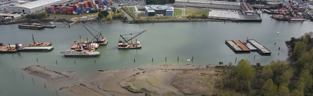
Construction in the upper reach is underway
LDWG is nearly complete with its second construction season (October 2025 – February 2026) in the upper reach, the uppermost segment of the project area. We expect construction in the upper reach to last one more season and reach completion in February 2027.
After LDWG completes cleanup in the upper reach, cleanup construction will continue with the middle and lower reaches, with construction activities ending at the south end of Harbor Island.
We are using a few methods to clean up the waterway sediment, including dredging, capping, and natural and enhanced recovery processes. Visit our Sediment Cleanup webpage to learn more about how we clean up the river.
Stay updated on upper reach construction by visiting the Construction News page.
Cleanup design for the Lower Duwamish Waterway
The first step in the design process is to conduct pre-design investigations – in this step, scientists and engineers gather more data about contamination and site conditions in the waterway. Engineers use these data to define which areas need cleanup and decide which cleanup technologies can be used to meet EPA’s cleanup plan requirements in specific locations.
The design goes through three stages before it is finalized: 30%, 60%, and 90%. Each stage provides more information and detail about the design. EPA oversees all steps of the design process and will lead public involvement and engagement through their Roundtable and Stakeholder meetings during the pre-design and design phases to set the final cleanup design.
As part of the design process, LDWG gathers feedback from the broader community to anticipate potential concerns related to cleanup construction on each segment. LDWG compiles this information into a Community Impacts Mitigation Plan (CIMP). The CIMP for the upper reach was completed in 2024.
- Read the full CIMP for the upper reach
- Read the CIMP summary for the upper reach: English CIMP Summary | Spanish CIMP Summary | Vietnamese CIMP Summary | Khmer CIMP Summary
A Seat at the Table
EPA has convened a Roundtable to help affected communities and local agencies work together to mitigate the impacts of cleanup. The Roundtable brings together governments (federal, tribal, state, and local) and other interested parties (e.g., residents, businesses, industries, labor, neighborhood groups, waterway users, fishers, and others) to share information and make recommendations during the design and implementation of the cleanup plan. You can read more about the EPA’s Roundtable on their Lower Duwamish Waterway Roundtable website.
Upper Reach Cleanup Design
In 2020 and 2021, scientists and engineers completed two phases of pre-design investigation work for the upper reach. We completed the 30% Remedial Design in 2022 and, in February 2023, submitted the 60% design to EPA. In December 2022, we collected additional investigation samples and used that data to refine cleanup areas in our 90% Remedial Design. We submitted 90% Remedial Design to EPA in July 2023 and completed the final design for the cleanup in January 2024. Remedial design for the upper reach cleanup is now complete and cleanup construction is underway. Read about upper reach construction on our Construction News page.
Middle Reach Cleanup Design
We began collecting sediment samples as part of pre-design investigation work in December 2022. The design process for the middle reach of the Lower Duwamish Waterway is underway. Our scientists are gathering data about the contamination, and our engineers use this data to verify that the design meets U.S. Environmental Protection Agency’s (EPA) cleanup plan requirements. We will be collecting additional investigation samples in 2026 to use in our 90% Remedial Design. We expect to finish the cleanup design for the middle reach in 2027 and begin cleanup construction as soon as fall 2028.
Upper Reach of Lower Duwamish Waterway
Middle Reach of Lower Duwamish Waterway
Lower Reach Cleanup Design
In 2025, we began conducting pre-design work for the lower reach. The lower reach is the northernmost 1.6 miles of the Lower Duwamish Superfund Site. During this pre-design phase, LDWG is developing remedial design work plans and will begin conducting pre-design investigations including sampling and surveys in 2027.
Lower Reach of Lower Duwamish Waterway
Cleanup Construction Schedule for the First Two Reaches
Cleanup construction in the upper and middle reaches of the Lower Duwamish River is expected to begin in late 2024 and late 2027, respectively.
Upper Reach Remedial Design Timeline
Timeline graphic below shows:
- Remedial design planning—January 2019 through Quarter 1 2020
- Three phases of predesign investigation:
- Phase 1: Define cleanup areas—Quarter 2 2020 through Quarter 1 2021
- Phase 2: Refine cleanup areas and collect engineering data—Quarter 2 2021 through early 2022
- Phase 3: Fill remaining data gaps if needed—Quarter 2 2022 through Quarter 1 2023
- Four phases of remedial design:
- 30%—Quarter 4 2021 through Quarter 1 2022
- 60%—Quarter 2 2022 through Quarter 4 2022
- 90%— Quarter 1 2023 through Quarter 2 2023
- 100%— Quarter 3 2023 through Quarter 4 2023
- Construction contracting and work plans— Quarter 1 2024 through Quarter 3 2024
- Construction start goal—Quarter 4 2024

Middle Reach Remedial Design Timeline

Lower Reach Remedial Design Timeline
Timeline graphic below shows:
-
- 2025-2026: Remedial Design Planning and Pre-Design Investigation Workplans Development
- 2026-2027: Phase 1 Pre-Design Investigation – Define cleanup areas
- 2027-2029: Phase 2 Pre-Design Investigation – Refine cleanup areas and collect engineering data
- 2029: 30% remedial design
- 2030: Phase 3 Pre-design Investigation – Fill remaining gaps if needed
- 2030: 60% Remedial Design
- 2030-2031: 90% Remedial Design
- 2031: 100% Remedial Design
- 2031: Construction Start TBD Following Middle Reach Construction

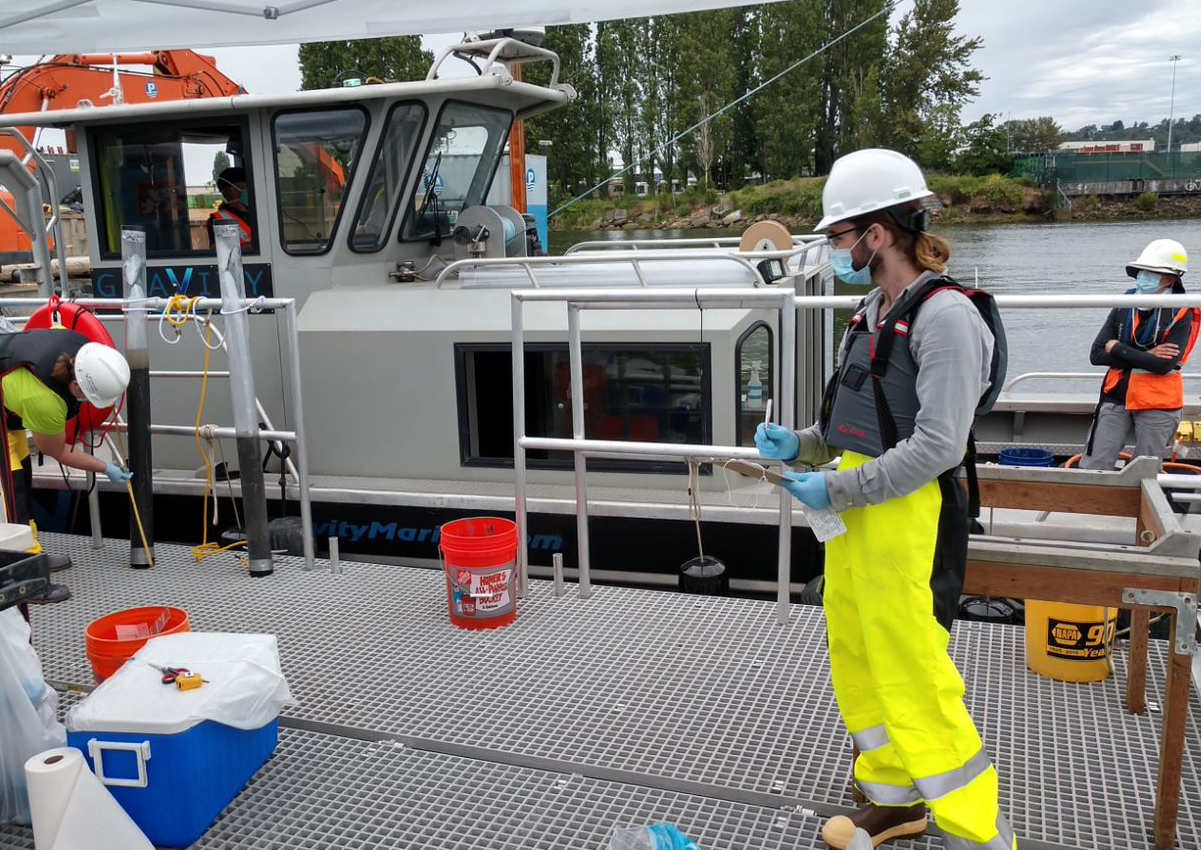
Summer 2020, LDWG and its contractors collected samples of sediment to test for contaminants of concern. This information contributed to the remedial design.
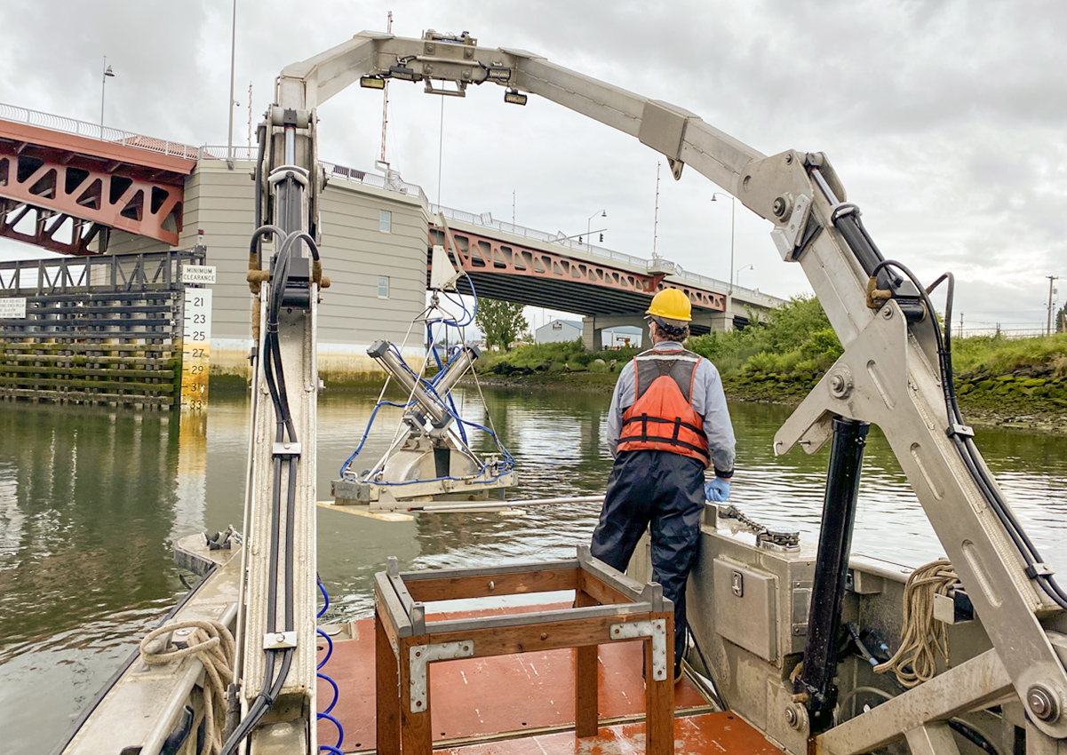
Phase 1: Crews collect a “grab sample” from the Upper Reach of the Lower Duwamish. Photo: Windward Environmental LLC
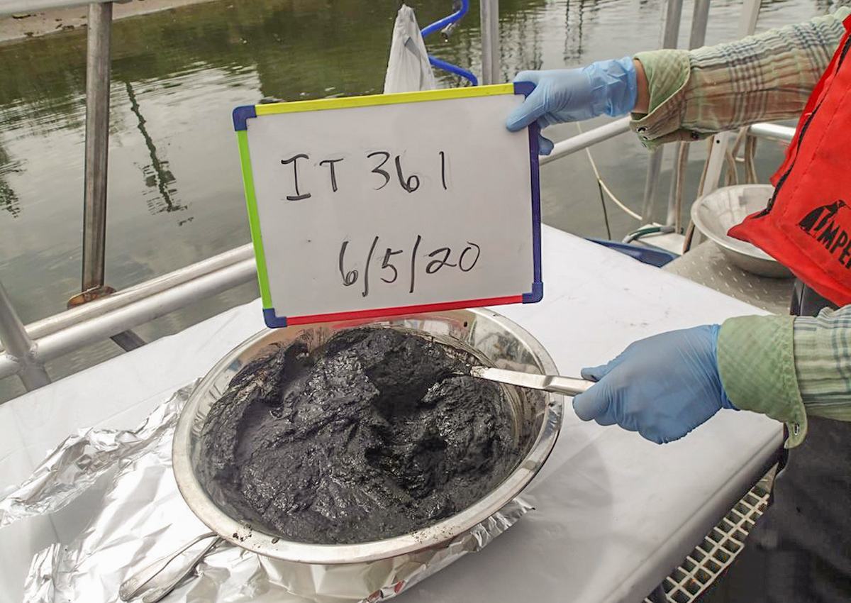
Phase 1: Example of a “grab sample” collected in June 2020. Photo: Windward Environmental LLC
Phase 1: Sample transfer of Lower Duwamish Upper Reach. Photo: Windward Environmental LLC
Controlling Sources of Contamination
The members of LDWG work together with EPA and Ecology to keep new and ongoing sources of pollution out of the river.
Contaminants in soil and groundwater on sites around the river can find their way into the river through storm runoff, spills and leaks, industrial discharge, erosion and leaching, and other pathways. Ecology is leading efforts to control sources of contamination from areas upland of the waterway, and EPA is leading efforts to clean up the river sediments. The long-term goal is to minimize re-contamination of the river sediment and restore the river’s water quality.
King County and the City of Seattle have helped hundreds of individual businesses and property owners address problems with hazardous materials, industrial wastewater, stormwater, spill containment, and leaking pipes. LDWG members are also working with agencies to improve the health of the Green/Duwamish watershed, restore natural resources, and further protect fish and wildlife habitat. King County and the City of Seattle are working toward improved water quality with large investments in controlling combined sewer overflows and improving stormwater quality.